About

Bermuda Triangle

Bigfoot

UFOs

Occult

Cold Case Files


BiminiS

Maps of Atlantis — The Buache Map

I  first wrote this page about the turn of the century and here re-upload it March 2024, minus some of the passion of youth chewing everybody out.

     Kept in the Library of Congress in Washington D.C., the Buache Map is often touted by Atlantologists as evidence there had once been an advanced prehistoric super civilization. Overall, it is the extraordinary preponderance that there is no ice on Antarctica and that the continent itself appears on maps before it was discovered. This impresses many Atlantologists that this map is older than the glaciation of the continent which they say occurred about 6,000 years ago.

     Pretty much reflecting this view, Charles Berlitz (The Bermuda Triangle) described it as:   “. . .copied from ancient Greek maps, showing Antarctica without the ice. If the ice did not presently cover Antarctica, the Ross & Weddell Seas would unite in a gigantic strait separating Antarctica into two land masses, a fact which was not established until the Geophysical Year of 1958. This map is another indication of surprising technological capabilities of some of ancient cultures.”

     As late as 1995, Graham Hancock, late of his search for the lost Ark of the Covenant, wrote in his voluminous Finger Prints of the Gods pretty much the same thing. “Philippe Buache, the eighteenth century French geographer, was also able to publish a map of Antarctica long before the southern continent was officially ‘discovered.’ And the extraordinary feature of Buache’s map is that it seems to have been based on source maps made earlier, perhaps thousands of years earlier,* than those used by Oronteus Finaeus and Mercator. What Buache gives us is an eerily precise representation of Antarctica as it must have looked when there was no ice on it at all.* His map reveals the subglacial topography of the entire continent, which even we did not have full knowledge of until 1958. . .” (*italics his)

     Such reflections of geographic knowledge of a prehistoric Earth has been proposed by several Atlantologists as a leftover from Atlantis and its world straddling empire, or from aliens who visited the Earth in ancient times, the “Ancient Astronaut Theory,” so popular in the early 1970s from Erich von Däniken’s phenomenally popular Chariots of the Gods, though he does not mention the Buache Map specifically.

     Apparently these writers did no research for themselves, but merely repeated one another. This seems probable for a variety of reason, especially since the map was made in 1739 as it states, not 1737 as they all write; that erred date can be traced back to a typo 50 years ago. Many, including Berlitz and Hancock, reproduce the map in their books, yet I suppose never bothered to read what it said.

Buache

     The Buache Map. It is seldom ever blown up enough in books to allow the reader to actually examine it.  According to the bottom of it, it was printed “At Paris, on the Quay of the Magifferie at St. Espirit, near the Pont Neuf under the auspices of the Royal Academy of Sciences, the 3rd of September, 1739.” Click to enlarge

     Below is a translation of the French on the map. It describes both the voyages of the ships of the expedition which led to this map. Plus, on the right, it records those responsible for its production. Below this, with blowups we will look at certain key areas of the map.
 

Extract of the voyage to the southern lands

1738, July 19, the 2 frigates the Aigle and the Marie left a port of the Orient; the 8th of September they passed the Ligne [equator]; the 11th of October they arrived at the Island of St. Catherine on the coast of Brazil; the 13th of November they set sail from this island for to go search latitude 44o by 355 longitude. On the 26th a thick mist at 35o lat. and 334 long.— often one cannot distinguish the objects at a gun port. It lasted until 20th January. Dec. 3, at the beginning, they begin to see the Geuemon(?), strong large whales, and birds at 39o 20 min latitude and 351 longitude. Believing themselves near to some land, they sounded without finding ground even at 180 fathoms.
   The 7th Dec. Weather cold although it is now Summer and the sun draws nigh the solstice. The 10th of Dec, lat. 44o and under the Prime Meridian: The “Land of View” is placed in this area by some geographers. One was not able to discover any such land, either because it has been mischarted or there is no such island. The 25th: on the Paris Latitude, longitude 7o; The air is very frigid. Saw several icebergs which has made us suspect land is nearby. The 21st: latitude 51o 23’ longitude 15o 22’— the gusts give on with varying and differentiating irregularity—  tried again in approaching the icebergs in the Bay of Hudson and in the -- of Davis.
1739, 1st of January: See fall of land, strong and high, at 54o latitude, and at 23o 30’ longitude– and there named it Cape of the Circoncision. Tarried 12 days without being able to land there on account of the icebergs, the mist and the contrary winds. 12th through 25th on course to 51o latitude during --- longitude seeing whales, etc.
4th February,  at 44o 30 latitude and at 6o longitude the vessels separate: Mr. Bouvet to make route to the Cape of Good Hope and Mr. Hay to Isle de France. The 4th of March cast anchor at Cape of Good Hope where he reckoned we had been within reach of l’E.(?) (icebergs) based on the course conjecture from the 25th of January.
   The 31st departed the Cape for France. Arrived in France the 24th of June without loss of any man in spite of the extreme fatigue of the voyage.

Translation of text on right of map.

 MAP OF THE SOUTHERN LANDS, encompassing the area between the Tropic of Capricorn and the Antarctic Pole, where one sees the new discoveries made in 1739 south of the Cape of Good Hope.
  BY THE ORDERS OF THE GENTLEMEN OF THE INDIA COMPANY.

Drawn from the memories and from the original map of Monsieur de Lozier Bouvet Chargé of this Expedition.

By Philippe Buache, of the Royal Academy of Sciences, son-in-law of the late Monsieur Delisle, Personal Geographer of the King, of the same academy.
___________________
     Augmented with various physical views [chart details] etc. 1754
____________________
OUTSERT  Plan and view of the lands of the CAPE OF THE CIRCONCISION, situated at 54 degrees of Latitude Meridian and around 27 degrees 30 minutes of Longitude.
 

Antarctica

         The real Antarctica

Fish1

     Well, of the “Extract Of The Voyage” some is conjecture, and there are a couple of  words I could not read– abbreviations, old French nautical terms and 250 year old idioms. Even a 19th century French-English dictionary did not help. But the point is made that the vessels were scouting the Antarctic ice flow. As the outsert of the map shows in the outsertenlargement (right), they were sure land was seen, but they could not approach it due to the icebergs and frigid winds.
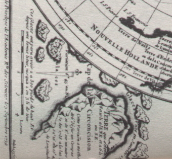
The outsert on the Buache Map describing the Cape of Circoncision. It reads: “These iceburgs [glaciers] are from 2 to 300 feet high. And from one half league up to 2 or 3 leagues of circumphrance.”

   This is not a map that Philippe Buache simply charted from old Greek maps that came from Atlanteans. These are nowhere mentioned. The map is a massive composite of deductions based on several explorer’s reports. Besides the routes of the Aigle and Marie, the chart holds courses described by Amerigo Vespuce (after whom America is named), and the route of Abel Tasman in 1642/3, some 100 years prior to this voyage. It is from all  these reports of latitude and longitude that Philippe Buache designed the map.

     Enlarging portions of the Buache Map helps us to see this. It is plain to see that New Zealand (Nouvelle Zelande) was considered attached to Antarctica. It had not yet been circumnavigated in Tasman’s time, and it is from Tasman’s 100 year old report that Buache was working. Buache had only Tasman’s report of his position when he entered the Bay of Assasins and the nearby Isle of the Three Kings, which he discovered in January 1643, as the map says. From this to the ice flow, Buache drew a line, presuming it was all land, thereby making a huge continent. New Zealand has not drifted nouvelleZ to its present spot. The map clearly marks its correct relationship to 30o SL and the Tropic of Capricorn. Because of this the coastline is very close to Terre de Deimen— Land of Demons, in other words, Tasmania. In several areas of “Antarctica” Buache placed Soupconnées and Conjecturée— suspected and conjectured. 
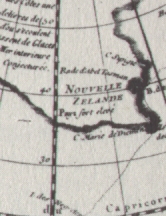
Portion of the Buache Map showing New Zealand (Nouvelle Zelande) as attached to Antarctica.

     It is shocking that anybody would claim the Buache Map is a copy of mysterious ancient Greek maps, which in turn were copied from Atlanteans or whomever. French is a common enough language to read and write. The map plainly declares its provenance as based on the “memories and the original map of Mr. Bouvet, who was in charge of the expedition.”
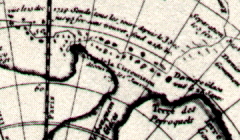
   buacheburgs   Ice, glaciers and freezing temperatures are repeating themes on the map. This is not Antarctica before the ice age. The Buache Map shows icebergs all over the area.

The course of the frigates charted between the icebergs at Cap de la Circoncision. It reads “The view of 3 Dec, 1738; Sounded all the area from December 3 until February 4 without finding any bottom.” The line shows their course back to Cape of Good Hope, Africa.

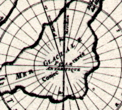
     The 18th century view was that icebergs originated from the run off of rivers into freezing bays. In order to account for so many of the size they saw, they deduced there must be a huge “Bassin terrestre” or inner harbor beyond the ice shelf into which the rivers must run. The icebergs would make their way out to sea via 2 large debouquements (outlets) of the Mer Glaciale (Glacial Sea), the name they dubbed this hypothetical bay. They believed Antarctica must have rivers “as considerable as those of Siberia which create the icebergs of the North.”
merglaciale
   The imaginary MER GLACIALE.  A Note on the chart suspected it was even bigger than this (the “inner harbor” of the rivers) in order to contain all the flow of the rivers which then froze creating the huge icebergs. The icebergs then drifted out of the Mer into the ocean by Cap de la Circoncision. This was suspected, while the above shape was merely conjecturée.

     This strait that connects the Weddell and Ross seas is merely expressing that conjecture about iceberg creation. But the map plainly says the area is conjecturée. Today, we know there is a land bridge. However, from the extreme distance from which the readings had been taken (since the ships could not get close on account of all the surrounding ice) they merely assumed the vast sea of ice shelf attached over the horizon.

     This “sea of ice” has its direction all fouled up as well, something a satellite photo would not show, nor a super civilization chart. It points toward Africa and Madagascar. This is certainly not what the much referred to 1958 geophysical year discovered in soundings. It is amazing this map has been touted as “exactly what Antarctica would look like if the covering ice were removed.”


bottombanner-left

Home

Bermuda

Sargasso Sea

Miami

San Juan

     500 Leagues of Sea


CofD
Bottom-right